NAFTA Superhighway History*
Metropolitan Planning Organizations (MPO)
The Federal-Aid Highway Act of 1962 came with the requirement for urban transportation planning for metropolitan areas - defined as having a population of 50,000 or greater. Evolution of the comprehensive planning process:
"By July, 1965, all the 224 existing urbanized areas had an urban transportation planning process underway. At that time, qualified planning agencies to conduct the transportation planning process were lacking in many urban areas. Therefore, the Bureau of Public Roads (predecessor to the Federal Highway Administration) required the creation of planning agencies or organizational arrangements that would be capable of carrying out the required planning process. Hence, Metropolitan Planning Organizations (MPOs) quickly came into being because of the growing momentum of the highway program and the federal financing of the planning process."1
There has been so much controversy and disinformation about the NAFTA Superhighway, that several researchers - including myself - undertook the project of researching the origins of the name NAFTA Superhighway, to be able to document it to the extent that denials are impossible and to define precisely what it means both now and into the future.
Thanks to the efforts of Debra Niwa, Independent Researcher and Graphics Artist, Amanda Teegarden, Ok-Safe, a host of others I can't name, plus a special thanks to Jane Lesko, Eagle Forum of Idaho who prodded me to investigate the Canamex even though looking at highways was the last thing in the world I wanted to do.
The Federal Highway Administration defines MPO6 as follows:
1) Regional policy body, required in urbanized areas with populations over 50,000, and designated by local officials and the governor of the state. Responsible in cooperation with the state and other transportation providers for carrying out the metropolitan transportation planning requirements of federal highway and transit legislation. 2) Formed in cooperation with the state, develops transportation plans and programs for the metropolitan area. For each urbanized area, a Metropolitan Planning Organization (MPO) must be designated by agreement between the Governor and local units of government representing 75% of the affected population (in the metropolitan area), including the central cities or cities as defined by the Bureau of the Census, or in accordance with procedures established by applicable State or local law (23 U.S.C. 134(b)(1)/Federal Transit Act of 1991 Sec. 8(b)(1)). (FHWA2)
I hadn't thought about that program in years until I started researching the NAFTA Superhighway. The NAFTA Superhighway is the implementation of one of the Big Dreams from the 1960's.7 The dream was an intelligent highway system with intelligent cars that would have collision detection and prevention systems; traffic flow control systems; your car would talk to you and tell you the best route to take and it would give you road conditions ahead. It was fantastic and just the prospect of it was exciting. But here we are in the 21st Century and we are facing the reality of the Big Dream becoming the Big Nightmare - with the Big Nightmare being defined as the NAFTA Superhighway.
The North Central Texas Council of Governments (MPO) regional transportation plan - named Mobility 2000, was the first major metropolitan area planning project that was given the mandate to design a comprehensive plan utilizing the concepts of the 'intelligent highway' technology. 'Superhighway' is the label that was given to describe an 'intelligent highway' to differentiate it from an ordinary, non-automated highway. The history of the Mobility 2000 project is on the right panel.
Intelligent Vehicle Highway System (IVHS)
Strategic
Plan
At the DOT's request, IVHS America produced a Strategic Plan for for America's transportation infrastructure. This plan was produced concurrently with the Intermodal Surface Transportation Efficiency Act of 1991.
"DOT asked IVHS AMERICA to draw on its membership to develop a Strategic Plan for IVHS in the United States and set it in an international context. This document is that Strategic Plan. Written by the Strategic Planning Subcommittee of IVHS AMERICA, it can fairly be called a consensus of the IVHS community in the U.S." 13
This group was essentially given carte blanch to redesign America's transportation and border infrastructure for the purpose of building world's first fully automated, advanced technology highways and facilities, managed by information and control systems.
IVHS is, in fact, a paradigm shift. The transportation/information infrastructure is a new way of looking at, thinking about, and improving mobility - a sociological as well as a technological revolution. The shift is ongoing in air and rail transportation. That paradigm shift is needed in highway and public transportation as well.14
Mobility 2000
Mobility 2000 was the name of the Dallas-Fort Worth federally mandated, regional transportation study8 that was completed in 1986. Two years later, after a conference attended by various groups involved in road and traffic management, a national special interest group was formed. They named themselves Mobility 2000.9
"In 1988, Mobility 2000 was formed to develop a national program of automated highway technology, which eventually evolved into Intelligent Transportation systems (ITS). Mobility was the organizational precursor to ITS America, of which AASHTO [American Association of State Highway and Transportation Officials] was a founding member". 10
"Founded in 1988, Mobility 2000 was an informal assembly of industry, university, and government representatives created to promote the use of advanced technologies to improve highway safety and efficiency. The initiative was formalized in 1991, when the Intermodal Surface Transportation Efficiency Act (ISTEA) was enacted, and the national Intelligent Vehicle Highway System (IVHS) program was established. A growing sense soon developed in the IVHS community, especially in the public transit arena, that “intelligent vehicle highway systems” did not embrace all the transportation modes addressed in the national IVHS program. In 1994, the national IVHS program was renamed the Intelligent Transportation System (ITS), to clarify the multi-modal intent." 11
"In 1991, the Intermodal Surface Transportation Efficiency Act (ISTEA) provided this initial funding and authorized the organization to be a Federal Advisory Committee to the U.S. Department of Transportation. Among its first major tasks was the development of a strategic plan for ITS deployment in the U.S. The document was a collaborative effort among the organization’s membership and the U.S. DOT set a national framework for guiding the development of intelligent transportation systems."12
Paradigm Shift in Transportation Policy
The shift in transportation policy away from just building highways and moving us towards the 21st Century Nightmare began with the Intermodal Surface Transportation Efficiency Act of 1991 (ISTEA). In that legislation, Congress declared the Dwight D. Eisenhower National System of Interstate and Defense Highways (Interstate System) complete and the 'National Highway System (NHS)' was created. The NHS included not only the Interstate System but also the feeder routes (urban and rural) leading to principal arterials and highways (including toll facilities), ports, airports, public transportation facilities, and other intermodal transportation facilities.
The purpose of the legislation was described thusly:
`The purpose of the National Highway System is to provide an interconnected system of principal arterial routes which will serve major population centers, international border crossings, ports, airports, public transportation facilities, and other intermodal transportation facilities and other major travel destinations; meet national defense requirements; and serve interstate and interregional travel16
It doesn't seem out of line to consider that the ISTEA legislation federalized the entire U.S. system of roads because all roads feed into - or lead to one of the major hubs mentioned above - except perhaps for Alaska where they have a road to nowhere. Maybe that was an act of rebellion on the part of Alaskans.
The following is an excerpt from a letter written by Federico Peña, Secretary of Transportation to Senator John Chafee, Chairman of the Committee on Public Works and the Environment in 1996 concerning a report regarding highway designations for the National Highway System:
Section 1006 of the Intermodal Surface Transportation Efficiency Act of 1991 (Public Law 102-240) authorized the NHS. However, the act made clear that the NHS was not intended to be simply a highway system. Rather, it was intended to provide the links that would unite a national intermodal transportation network in a unified, interconnected manner.
In December 1993, the Department submitted its recommendations to Congress for designation of the NHS. The recommendations included some connections to intermodal terminals, but the Department's report noted that the proposals received from the State transportation departments were not sufficiently consistent to warrant final designation of all connectors. The 1995 act, which designated the NHS, directed the Department to submit, within 180 days of enactment, modifications to the NHS to provide connections "…to major ports, airports, international border crossings, public transportation and transit facilities, interstate bus terminals, and rail and other intermodal transportation facilities." These connections, which are eligible on an interim basis for NHS funding, are subject to approval by Congress.17
Both the letter and the report: Pulling Together: The National Highway System and Its Connections to Major Intermodal Terminals can be found on the Federal Highway Administration website. If for some reason, access to the report is not available, a pdf has been captured and may be accessed HERE.
Intermodal Surface Transportation Efficiency Act of 199115
SEC. 2. DECLARATION OF POLICY: INTERMODAL
SURFACE TRANSPORTATION
EFFICIENCY ACT.
It is the policy of the United States to develop a
National Intermodal Transportation System that is
economically efficient and environmentally sound,
provides the foundation for the Nation to compete
in the global economy, and will move people and
goods in an energy efficient manner.
The National Intermodal Transportation System
shall consist of all forms of transportation in a
unified, interconnected manner, including the
transportation systems of the future, to reduce
energy consumption and air pollution while
promoting economic development and supporting the
Nation's preeminent position in international
commerce.
The National Intermodal Transportation System
shall include a National Highway System which
consists of the National System of Interstate and
Defense Highways and those principal arterial
roads which are essential for interstate and
regional commerce and travel, national defense,
intermodal transfer facilities, and international
commerce and border crossings.
The National Intermodal Transportation System shall provide improved access to ports and airports, the Nation's link to world commerce.
The National Intermodal Transportation System shall be adapted to ``intelligent vehicles'', ``magnetic levitation systems'', and other new technologies wherever feasible and economical, with benefit cost estimates given special emphasis concerning safety considerations and techniques for cost allocation.
* * * * *
Corridor: A combination of modes that move people, vehicles and goods from one location to another. In general, a transportation corridor is not just one road or rail line, but a combination of modes.18
Intermodal: being or involving transportation by more than
one form of carrier during a single journey.19
Transportation Corridors
The planning for the National Highway System in the ISTEA legislation included preservation of existing Interstate routes that would later be designated as high priority corridors.
Section 1017. Acquisition of Rights of Way
(c) Preservation of Transportation Corridors Report.-The Secretary, in consultation with the States, shall report to Congress within 2 years after the date of the enactment of this Act, a national list of the rights-of-way identified by the metropolitan planning organizations and the States (under sections 134 and 135 of title 23, United States Code), including the total mileage involved, an estimate of the total costs, and a strategy for preventing further loss of rights-of-way including the desirability of creating a transportation right-of-way land bank to preserve vital corridors.20
The transportation corridors were named as high priority corridors in 1995 in the National Highway System Designation Act (P.L. 104-59).
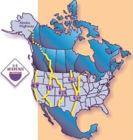
The following are two of the designated priority corridors:
Sec. 332. High Priority Corridors, (Items 26 and 23).21
(26) The CANAMEX Corridor from Nogales, Arizona,
through Las Vegas, Nevada, to Salt Lake City,
Utah, to Idaho Falls, Idaho, to Montana, to the
Canadian Border as follows…:(23) The Interstate Route 35 Corridor from Laredo,
Texas, through Oklahoma City, Oklahoma, to
Wichita, Kansas, to Kansas City, Kansas/Missouri,
to Des Moines, Iowa, to Minneapolis, Minnesota, to
Duluth, Minnesota.
Clearly, the NAFTA
Superhighway is the I-35 Corridor even though it was never
formally designated as such - probably for political
reasons.
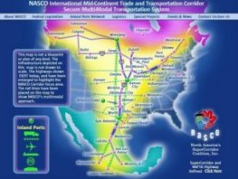
The I-35 Corridor is currently named the 'NASCO Corridor' after the group that lobbied for the superhighway designation:
"NASCO has assisted in the lobbying effort to bring hundreds of millions of dollars to the NASCO Corridor since 1994. The group’s efforts resulted in High Priority Corridor designated status for all 1,500 miles of I-35 from Laredo, Texas to Duluth, MN in 1995 and inclusion of same within the National Highway System under the Intermodal Surface Transportation Efficiency Act (ISTEA)." 22
North American Super Corridor Coalition (NASCO)
NAFTA Superhighway
The first reference to 'NAFTA Superhighway' was found in the Congressional Record in the Transportation and Infrastructure Committee hearings in 1995. The result of these hearings was the National Highway System Designation Act of 1995 23.
March 10, 1995, Page 687-688, remarks by Mr. Geren:
"NAFTA presents us with the greatest opportunity in world trade, in spite of the problems that Mexico is suffering through right now. For the long term, NAFTA, with what it offers with Canada and Mexico, presents us with the greatest opportunity for economic improvement in our country that we have seen in a long, long time. It is an opportunity for us to grow our markets, an opportunity for us to build good- paying, good-benefits jobs, not just in Texas, but all over the United States. And it is essential that we plan our transportation infrastructure based on what this international trade is going to require.
[…]
I think this NAFTA superhighway is a very important step in the right direction.
If you look at the map over there, I think it is self- evident what it means to the whole country, not just to Texas. And if you look at the NAFTA corridor as the trunk of a tree, one that hooks up Mexico and all those markets down there with the industrial heartland of our country, as well as the most important economic centers in Canada.
I urge this committee to give careful consideration to this concept. As this trade grows, the current I–35 won't be able to handle it. It will deteriorate. We won't take advantage of all the imaginative opportunities that this superhighway designation can give us.
Some of the ideas that have been mentioned to me that seem to make so much sense—if we could come up with a system where you can pack beef in Chicago, have it go through customs in Chicago and perhaps put a bar code on the truck, and have that beef be shipped right down and go straight into supermarkets in Mexico and not have to stop at the border crossing—there are so many imaginative things that can come out of it if we do put our best minds to work on maximizing the potential here.
Page 690 The designation of I-35 corridor as a superhighway under NAFTA is extraordinarly important to the successful implementation of that agreement.
Page 699 Excerpt from Remarks of Mr. Cornelius:
I really believe that the intelligent vehicle highway system, the IVHS program, represents our best opportunity to accomplish those goals, and IH-35 represents not only the State's, but I believe the Nation's most viable candidate for becoming the first of these new generation of superhighways.
GLOBAL TRANSPORTATION SYSTEM
Without a systems background, it's difficult to fathom the scope and complexity of the transportation infrastructure and integrated systems that are being implemented worldwide. In this country, we see a small part of it in the NAFTA Superhighway and Canamex and SmartPorts, but that's not even close to the full extent of it. This section and the next will attempt to expand the vision so that the magnitude and the implications of it can be understood. (And you'll wonder who is in charge of U.S. National Security and what they are doing with their time because it isn't being spent on protecting our nation).
This is an excerpt from the 1992 IVHS Strategic Plan:
"The mission of the IVHS community in the U.S. - composed of all levels of government; the automotive, electronic, communications, and information industries; and academia - is first, to improve surface transportation by deploying IVHS technology broadly throughout the nation and, in cooperation with Mexico and Canada, throughout North America, and second, to develop a U.S.-based IVHS industry to provide technology in the U.S. and abroad." 24
Section 1006 - ISTEA of 1991
(h) National Defense Highways Located Outside United States
-
(1) Reconstruction projects.-If the Secretary determines,
after consultation with the Secretary of Defense, that a
highway, or portion of a highway, located outside the United
States is important to the national defense, the Secretary
may carry out a project for the reconstruction of such
highway or portion of highway.25
The National Highway
System Designation Act of 1995
(P.L. 104-59) that was
signed by President Clinton on November 28, 1995 26
SEC. 359. MISCELLANEOUS
STUDIES.
(a) <<NOTE: 23 USC 309 note.>>
Pan American Highway.--
(1) Study.--The Secretary shall conduct a study on the
adequacy of and the need for
improvements to the Pan
American Highway.
(2) Elements.--The study shall include, at a minimum, the
following elements:
(A) Findings on the
benefits of
constructing a highway at
Darien Gap, Panama and Colombia.
(B) Recommendations for a
self-financing arrangement
for completion and maintenance of the
Pan American
Highway.
(C) Recommendations for establishing
a Pan American
highway authority to monitor
financing, construction,
maintenance, and operations of the
Pan American Highway.
(D)
Findings on the
benefits to trade and prosperity of a
more efficient Pan American Highway.
(E) Findings on the
benefits to United
States industry
resulting from the use of United
States technology and
equipment in construction of
improvements to the Pan
American Highway.
xxxxxxxxxxxxxxxxxxxxxxxxxxxxxxxxxxxxxxxxxxxxxxxxxxxxxxxxxxxxxxxxxxxxxxxxxxxxx
Texans Fight Against Trans-Texas Corridor (TTC)
The TTC would be operated by a Spanish firm known as Cintra that would reap the profits while partnering with U.S. politicians to ensure that eminent domain and law enforcement powers are wielded.
The same system mega-transport projects including 'intelligent highways' is being implemented in Europe as well as the United States and the systems are integrated making the Global Transportation Network - truly global - and truly a threat to U.S. national security. One does not need to be a military strategist to know that whoever controls the supply lines - controls the battlespace and wins the war.
(Concesiones de Infraestructuras de Transporte, S.A.) does business in Spain, Italy, Portugal, Canada, Chile and the United States. Recently the holding acquired from VINCI the “Autopista del Bosque” , a 160 km long stretch of the Ruta 5 South in Chile. Therefore, 5 continuous sections in Ruta 5, the Southern backbone, will be wholly operated by CINTRA for a total length of 890 km.In the United States, CINTRA already controls the Indiana Toll Road and the Chicago Skyway. In addition, CINTRA has recently submitted, among others, proposals for the construction and operation of a toll motorway for trucks in Atlanta, for the Ohio Turnpike and Texas Loop 9 Tollroad. At the end of September 2006, 67% of revenues* stemmed from overseas concessions.
Trans-European Transport Network
"In contributing to the implementation and development of the Internal Market, as well as re-enforcing economic and social cohesion, the construction of the trans-European transport network is a major element in economic competitiveness and a balanced and sustainable development of the European Union.
This development requires the interconnection and interoperability of national networks as well as the access to them.
Lastly, to achieve these objectives, the Community has established guidelines covering the objectives, priorities, the definition of projects of common interest, and the main themes of the envisaged measures.
The Trans-European Transport Network Executive Agency (TEN-T EA) was created in 2006 to implement and manage the TEN-T programme on behalf of the European Commission."
Learn more about the TEN-T EA
ERTICO - Prometheus
In order to bring products to market more quickly in Europe, European Road Transport Telematics Implementation Coordination Organization (ERTICO) was created in November 1991. Its objectives are to pool the information from the many individual projects and identify strategies in order to exploit the results of DRIVE, PROMETHEUS, and other individual programs. ERTICO's goal is to create a climate for market-driven investment in order to ensure European dominance in advanced-vehicle technologies.
About ERTICO
ERTICO - a multi-sector, public-private partnership pursuing
the development and deployment of ITS - exists to promote a
single successful pan-European ITS market and to ensure that
European interests are fully represented throughout the
world. Visit http://www.ertico.com
ITS – Intelligent Transport Systems and Services – is the integration of information and communications technology with transport infrastructure, vehicles and users.
By sharing vital information,
ITS allows people to get more from transport networks, in
greater safety and with less impact on the environment.
Only once travellers, vehicles and infrastructure can freely
exchange information will the capacity of the transport
network be fully utilised.
ERTICO strives for a European network in which roads and vehicles can communicate with one another; in which commuting is more secure, reliable and comfortable; in which businesses know where shipments are and what condition they are in and in which drivers are automatically directed to available parking spaces in urban areas.
EU transport "mega-projects" are threatening over a thousand protected nature sites in Europe, according to a coalition of European environmental groups.
Some of the most rare birds in Europe, including the Red-breasted Goose and the Dalmatian Pelican, as well as a range of biodiverse habitats could be put at risk by 21 planned "priority projects" that are part of the Trans-European Transport Network (TEN-T) package.
The TEN-T is the EU's transport infrastructure framework. Originally adopted in 1990, TEN-T is engaged aims to connect up tens of thousands or roads, railways and waterways across Europe by 2020.
ITS Associations World Wide - notice that ITS Arab doesn't have a flag yet, and neither does Taiwan. So - do you want to ask again why we attacked Iraq and took out Saddam? And why we attacked Afghanistan (hint: pipeline - energy corridor).
Plan Puebla Panama
"The PPP's main components call for massive state investments in infrastructure projects. Close to 84% of the funds initially appropriated are for highway construction and improvement along two axes: the Pacific and Gulf Coast corridors. The latter reaches beyond the PPP's geographical confines and stretches 1,745 km from Central America's Caribbean coast to the Mexican border with Texas. The Pacific Corridor will run 3,150 km from central Mexico to Panama City. Both projects, together with feeder roads, will cost over US$3.5 billion. Other projects include:
- Upgrading and linking the electrical grids of Central America and Mexico
- Supplying electricity into the ravenous US market
- Constructing 25 dams throughout the PPP area for hydroelectric generation
- Improving or building or new ports, airports and bridges
- Upgrading telecommunications facilities, including a fiber-optic network, already well underway
- Integrating protected wildlife reserves into "corridors", ostensibly to protect diverse species, but also facilitating bioprospecting by seed, chemical and pharmaceutical companies
- Improving tourist facilities and infrastructure"
"Free Trade" for Mesoamerica - Roads, Dams and Death
"The Slippery Slope - U.S. Military Moves Into Mexico"
ISTEA was planned as an international project from the beginning.
"Efforts already under way to create a North American IVHS program are consistent with recent developments toward increased economic cooperation between the U.S., Canada, and Mexico." 27
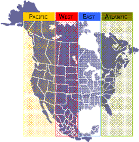
North American Trade Corridors28
(Source:
North American Forum on Integration)
Security and Prosperity Partnership (SPP)

Hudson Institute: 'Negotiating North America'
The SPP is about harmonizing regulations to facilitate the integration of the U.S., Mexican and Canadian economies and government regulatory rules and functions.
UNISYS - Videos on Information Systems Related to Global Transportation System
Trans-Texas Corridor (aka NAFTA Superhighway)
"The proposed system will be a network of transportation corridors (routes) incorporating separate lanes for passenger vehicles and trucks, rail lines for high-speed passenger and freight rail, and a dedicated utility zone. Components in the system may incorporate existing and new highways, railways, and utility rights-of-way where practical. Up to 366 meters (1,200 feet) wide in some places, the corridor is designed to move people and freight faster and more safely through Texas, from Mexico to the Oklahoma border."
Energy corridors proposed across public lands in West
Curiously however, the proposed utility and pipelines appear to be in the same location as the existing utility and pipelines lines so it's not clear why they would need an additional 3500 feet of right-of-way. 3500 feet is just under 10 football fields running end to end.
Priority Corridors
China-Mexico
COMMUNIST China's connection to the U.S. transportation system is being facilitated by their Mexican "partners" and NASCO. NASCO merged with an organization named the North American International Trade Corridor Partnership (NAITCP). Before the merger, NAITCP had their own website. On their website, there was a conceptual design document for a global freight tracking system that is integral to the design plans for the global transportation system.
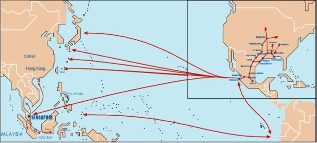
Excerpt from "The Trans-Pacific Multi-Modal Security System" (TPMSS) overview:
"An important step towards the further integration of Mexico with its APEC trading partners is the development of a modern multimodal security system between North America and Asia. The backbone of this new system will be frequent maritime routes between selected Asian ports and the Mexican ports of Manzanillo and Lázaro Cárdenas. These sea routes will be supported by enhanced rail service running through the heart of North America. TFM and Ferromex, in coordination with Kansas City Southern and Union Pacific, will be the workhorses hauling cargo north out of the ports of Manzanillo and Lázaro Cárdenas.
Manzanillo is Mexico’s busiest Pacific port and will be the first seaport incorporated into the Trans-Pacific Multimodal Security System (TPMSS). Subsequently, the port of Lázaro Cárdenas will be added to the program. Several Asian transshipment and gateway hubs such as Singapore, Hong Kong, Shanghai, and Kaoshiung could realize quantifiable long-term benefits by participating in this initiative. Cargo generation programs, customs modernization, infrastructure enhancements, operational improvements and the use of Intelligent Transportation Systems (ITS) will help justify frequent maritime service between Mexico and Asia....
The essence of the TPMSS is to build additional transportation capacity in APEC region, realize operational improvements, implementation of innovative security and customs protocols while providing Mexican businesses with direct access to globally competitive multimodal systems. The project proposes the development of a secure and agile transportation system to increase current capacity and, in the initial stages, will utilize the Kansas City SmartPort as its strategically located inland port in North America.
x
Trans-Pacific Multi-Modal Security System (TPMSS) Conceptual Design Diagram
TPMSS "Security"
For example, it is envisioned that goods shipped through the TPMSS could travel the following path. First, goods will undergo an initial security revision at the shipper’s location in Southeast Asia and/or during their transshipment in Singapore. Singapore will then send advance notification to Mexican and U.S. Customs with the corresponding “pre-clearance” information on the cargo. When the containers arrive at Manzanillo or Lázaro Cárdenas, they will proceed through an X-ray arc, but will not clear Mexican Customs. Any containers with anomalies will be removed from the special in-bond regimen. If no anomalies are detected, the containers will head north on double-stack unit-trains. The unit trains will be tracked by a GPS system and monitored by ITS during the entire journey. When the train reaches the U.S. border, the containers will pass through yet another X-ray arc, and will clear U.S. Customs under the new electronic manifesting system. Again, any containers with anomalies will be removed from the unit train and inspected immediately. The cargo will then travel non-stop on Kansas City Southern or Union Pacific trains, while being GPS/ITS tracked, to an inland trade-processing center in cities like Kansas City, Chicago, Ft. Worth or Oklahoma City. Upon arrival to the inland port the containers could be subjected to another full customs inspection and then trucked out to the final destination.
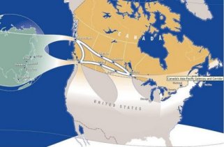
APEC Canada-Asia Gateway
If you control the supply lines, you control the territory.
If the enemy controls the supply lines, you're finished.
"Spending authority for the ITS program grew from $20 million in 1991 to $227.5 million in 1995. For the 1991-1995 period, the Congress has voted $827.6 million, and by the end of fiscal year 1994 the Department of Transportation had obligated $544 million for the program (see Summary Table 1)." 29
Part II - Smart Highway Technology
1) Association of Metropolitan
Planning Organizations, About MPO's: A Brief History,
(Excerpts from U.S. DOT's 1988 Report, Urban Transportation
Planning in the United States: An Historic Overview
www.Channelingreality.com/NAU/IVHS/MPO_Brief_History_AMPO.pdf
2) Debra Niwa, NAFTA
Superhighway Memory Hole, September 2007
http://www.channelingreality.com/Documents/NAFTA_Superhighway_07.pdf
3) Debra Niwa, NAFTA History
in Bulletins,
http://www.channelingreality.com/NAU/nafta_highway_history_bulletins.htm
4) OK-Safe, Inc.
http://www.ok-safe.com
5) Corridor Watch,
http://www.corridorwatch.org
6) Federal Highway
Administration, Planning Glossary, 6/16/2008
http://www.fhwa.dot.gov/planning/glossary/glossary_listing.cfm?TitleStart=M
7) U.S. Dept of
Transportation, Federal Highway Administration, Lyle Saxton,
"Mobility 2000 and the Roots of IVHS"
http://www.itsdocs.fhwa.dot.gov/JPODOCS/BRIEFING/9003.pdf
8) North Central Texas Council
of Governments, Metropolitan Transportation Planning,
Mobility 2000
http://www.nctcog.org/trans/mtp/previous/mob2000.asp
9) U.S. Dept of
Transportation, Federal Highway Administration, Lyle Saxton,
"Mobility 2000 and the Roots of IVHS"
http://www.itsdocs.fhwa.dot.gov/JPODOCS/BRIEFING/9003.pdf
10) Siradol
Siridhara, Virginia Tech Digital Library, 'AHS Maglev System
Architecture', Dissertation, URN: etd-100799-120014,
8/23/1999,
http://scholar.lib.vt.edu/theses/available/etd-100799-120014/
section referenced: Introduction - Page 2,
http://scholar.lib.vt.edu/theses/available/etd-100799-120014/unrestricted/1introduction.PDF
11) I-70 Rural IVHS Corridor Master Plan, Colorado Dept of
Transportation, De Leuw, Cather & Company, April 1996,
660205-01450
Appendix C--ITS Acronyms
http://www.itsdocs.fhwa.dot.gov/edldocs/3825/app-c.pdf
Recovered local copy:
http://www.channelingreality.com/NAU/IVHS/History_Docs/Corridor_master_Plan_CO_DOT_Appendix_C.pdf
(entire report)
http://www.itsdocs.fhwa.dot.gov/JPODOCS/REPTS_TE/3825.pdf
(very large pdf)
12) Intelligent Transportation
Society of America (ITS America) history, ITS America
website
http://www.itsa.org/itsa_history/c48/Inside_ITSA/ITS_America_History.html
(Note: former name was Intelligent Vehicle Vehicle Highway
Society (IVHS))
13) Strategic Plan for Intelligent Vehicle Highway Systems in
the United States, IVHS America, Report No: IVHS-AMER-92-3,
May 20, 1992, Page II-1 (pdf p.28)
http://www.itsdocs.fhwa.dot.gov/JPODOCS/REPTS_PR/1823.pdf
14) Strategic Plan for Intelligent Vehicle Highway Systems in
the United States, IVHS America, Report No: IVHS-AMER-92-3,
May 20, 1992, Page II-4 (pdf p.31)
http://www.itsdocs.fhwa.dot.gov/JPODOCS/REPTS_PR/1823.pdf
15) U.S. Dept of
Transportation, Research and Innovation Technology
Administration (RITA), H.R. 2950 Intermodal Surface Transportation Efficiency Act of 1991
(ISTEA),
http://ntl.bts.gov/DOCS/istea.html
16) U.S. Dept of
Transportation, Research and Innovation Technology
Administration (RITA), H.R. 2950 Intermodal Surface Transportation Efficiency Act of 1991
(ISTEA), National Highway System Replacement language for
Section 103 of Title 23 Section 1006 (a) (b) (1) Purpose
http://ntl.bts.gov/DOCS/istea.html
17) Federal Highway
Administration, Letter and report from Federico Pena,
Secretary of the DOT to Senator John Chafee, Chairman,
Committee on Environment and Public Works, May 24,1996,
Report title, "Pulling Together: The National Highway System
and Its Connections to Major Intermodal Terminals
http://www.ops.fhwa.dot.gov/freight/freight_analysis/nhs_connectors/nhs_its_con.htm
18) Federal Highway
Administration, U.S./Mexico Border Transportation Planning, Binational Border Transportation Infrastructure Needs
Assessment 2004, January 2004, Appendix 12 Glossary of
Terms, pg, 12-4
http://www.borderplanning.fhwa.dot.gov/BINSstudy/BINSApp12.pdf
19) Load Match, Inc.
June 16, 2008,
http://www.loadmatch.com/what_is_intermodal.htm
20) U.S. Dept of
Transportation, Research and Innovation Technology
Administration (RITA), H.R. 2950 Intermodal Surface Transportation Efficiency Act of 1991
(ISTEA), Section 1017(c)
http://ntl.bts.gov/DOCS/istea.html
21) U.S. Dept. of
Transportation, National Highway System Designation Act of
1995, Public Law 104-59, Nov. 28, 1995, Section 332 High
Priority Corridors,
http://frwebgate.access.gpo.gov/cgi-bin/getdoc.cgi?dbname=104_cong_public_laws&docid=f:publ59.104
22) North America's SuperCorridor Coalition, Inc. June 18,
2008, "The Transportation Infrastructure Challenge", NASCO
Solutions to Transportation Infrastructure Challenge,
http://www.nascocorridor.com/commondetail.asp?id=2168
23) D. Niwa, NAFTA Superhighway Memory Hole, page 1, 1995,
"Legislation to Approve the National Highway System (NHS)
and Ancillary Issues Relating to Highway and Transit
Programs (H.R. Trust Funds Off-Budget), U.S. House of
Representatives, Subcommittee on Surface Transportation and
Infrastructure, Washington DC, March 10, 1995.
http://www.channelingreality.com/Documents/NAFTA_Superhighway_07.pdf
24) Strategic Plan for Intelligent Vehicle Highway Systems
in the United States, IVHS America, Report No: IVHS-AMER-92-3,
May 20, 1992, Mission Statement, Page II-7 (pdf p.34)
http://www.itsdocs.fhwa.dot.gov/JPODOCS/REPTS_PR/1823.pdf
25) U.S. Dept of Transportation,
Research and Innovation Technology Administration (RITA),
H.R. 2950 Intermodal Surface Transportation Efficiency Act of 1991
(ISTEA), National Defense Highways Located Outside United
States Section 1006 (h)
http://ntl.bts.gov/DOCS/istea.html
26) U.S. Dept. of Transportation, National Highway System
Designation Act of 1995, Public Law 104-59, Nov. 28, 1995,
'Miscellaneous Studies, Section 359 (a),
http://frwebgate.access.gpo.gov/cgi-bin/getdoc.cgi?dbname=104_cong_public_laws&docid=f:publ59.104
27) Strategic Plan for Intelligent Vehicle Highway Systems
in the United States, IVHS America, Report No:
IVHS-AMER-92-3, May 20, 1992, Page I-15 (pdf p.22)
http://www.itsdocs.fhwa.dot.gov/JPODOCS/REPTS_PR/1823.pdf
28) North American Forum on
Integration website, June 18, 2008, "The North American
Trade Corridors"
http://www.fina-nafi.org/eng/integ/corridors.asp?langue=eng&menu=integ
29 Congressional Budget Office,
High-Tech Highways: Intelligent Transportation Systems and
Policy, October 1995
http://www.cbo.gov/ftpdocs/0xx/doc16/Highways.pdf Additional info on spending: http://www.cbo.gov/publications/bysubject.cfm?cat=21
